...check back for new pictures
to be added regularly....
to be added regularly....

| This photo shows the Citizen's Band of Schuylkill Haven in the 1920s. |


| THE RAID ON GESCHWINDT'S |
| The series of pictures below were taken after the raid on the home of Charles Geschwindt on Garfield Avenue on April 1, 1934. Seized were 225 gallons of wine, 13 cases of home brewed beer, two bottle cappers, a syphon hose and 24 empty cases. The story is on the Crime Page of this site. |
| Illegal booze and equipment with police officers in front of the old Town Hall on Dock Street. |
| Another view of the goods with the police on Dock Street looking toward Main Street. |
| The booze was loaded into a Schuylkill Haven Highway Department truck to be destroyed. |
| Police and unknown persons pose with the alcohol and equipment before its disposal. The background suggests this may have taken place at the town dump. |
| The goods go up in a mass of flames. |
| Photos compliments of Ellen Laurent. |


| Below are two more pictures of Bressler's Band from Schuylkill Haven. At left, the band parades moving west on Union Street between Saint Peter and Saint John Streets for the funeral procession for Lieutenant Roy Guertler in April of 1931. At right the band moves west on Main Street between Dock and Saint Peter Streets, date and event unknown. |

| This delivery truck originally belonged to Unger's Market on Columbia Street. It was purchased by Harvey Moyer, a farmer on the Schuylkill Mountain who used it to sell his goods in the area on Fridays. |

| This scene is from the Willow Lake swimming pool on Garfield Avenue, probably taken in the fifties or sixties. PHOTO COURTESY OF GREG KIRK |


| The two pictures to the left here, were taken during the sewer project on Market Street in the early 1950s. The views are looking east on Market Street from Saint John Street. The photo at right is 220 Saint John Street and shows Sterling and Helen Achenbach on the porch of the home where Sterling ran a one room grocery store from 1950-1956. PHOTOS COMPLIMENTS OF RICHARD ACHENBACH |


| The pictures below are homes in Schuylkill Haven in 1925. Top left photo is at the corner of Dock Street and Paxson Avenue, looking much as it does today. Top right is the old Pflueger home at Union and Saint Peter Streets taken from the latter. Middle left is in the 200 block of East Main Street and middle right is the home at Parkway and West Main Street, both looking similar today. Bottom left is West Main Street and bottom right is on Dock Street next to the old Borough Hall. |


| All pictures below are from the 175th Anniversary celebration held in 1925. The top two are buildings on Saint John Street. Below that are parade scenes including the State Police, Bressler's Band, Girl Scouts and the Ku Klux Klan. They are either taken on Saint John Street looking south from Union Street or on West Main Street above Saint Peter Street. |


| The following four pictures are compliments of Jim Creveling of Reading, who rescued these great photos from destruction. At top left is an image of a late ice harvest on Bittle's Dam (Stoyer's Dam) on March 25, 1906. It looks northeast from the south side of the dam. Top right shows Motzer's Bakery on Parkway between Main and Union Streets in 1880 on the east side of the canal. At bottom left is a picture taken March 18, 1932, ten days after the Hotel Grand fire. The view looks north from Wilson Street. The bottom right photo shows the Reading Railroad station under construction in 1901. |

| This image shows the George Bubeck home on Center Avenue. It is on the north side of the street south of the Dock Street intersection. |

| This photo shows the home located at 21 West Liberty Street. |


| At left is Vincent J. Dalton as a young boy. He later became a judge in Schuylkill County and lived in Schuylkill Haven. At an early age, he was picking coal along the Reading Railroad tracks. The train moved when his arms were under the wheels and they were mangled and had to be amputated. This is apparent in the picture when looking at his shirt sleeves. |
| Ehly's Bakery delivery truck probably in the 1950s. The driver may be employee Charles Heim. |


| At left is the intersection of Berne and Columbia Streets. The home being removed is on Columbia Street and the home above on Berne Street. Currently it is a vacant lot. The photo at right is from the blizzard on February 19, 1908. It is looking south on Dock Street near the Christ Lutheran Church now the location of Jerusalem Lutheran Church. |


| At left is a truck from Harvey Moyer towing a rail car on Center Avenue south of the Dock Street intersection. At right is the Reading Railroad signal tower at the Union Street crossing. Only a small concrete block remains at the location. |
| This is the Soldier's Memorial located on Parkway. |


| Both photos here are on Center Avenue in the vicinity of the current Reiley and Sterner garage. The garage pictured above in 1925 is still there in a different form. Note the gas station in the undated photo at left. |


| These three images are taken from the St. John's UCC anniversary book of 1962. At the top left is the view of the old St. John's Reformed Church at the corner of Main and Dock Streets, seen looking down High Street. Above right is the former Levan home which was torn down in 1905 to make room for a new parsonage which still stands today. At bottom left, the old church and the Meyer home on Main Street are shown. The building on the far left is the office of Dr. Kempes today. The home was removed in 1925 and the church torn down in 1927 after the current church was finished directly behind it. |


| At left, Bressler's Band gathers for a photo at the Kutztown fair, date unknown. At right, Michel's delivery truck takes time for a photo at an unknown location and date. |


| This picture was taken in about 1931 showing car dealer Earl Stoyer and heavyweight boxing champ Jack Dempsey in front of the Columbia Street location. |
| This group of Schuylkill Haven men gathered for a picture but the date and exact location is unknown. They are identified from left to right; First row: Bright Kantner, Willis Reed, Jim Schuckers, Mark Detwiler, Percival Heisler, Second row: Austin Faust, Merlie Fisher, Frank Witman, Claude Sausser, C. W. Faust, Bast, Hood: Harry Kerschner and Harry Moyer. |
| These two images depict the Long Run Hotel, located at the intersection of 183 and 443. Just after 1900, Joel Stoyer, father of Earl, took ownership from his inlaws. The building remains today. |
| This photo of the trolley was taken near Tumbling Run park at the turn of the last century. The man on the left is identified as "Pappy" Reber. |


| This set of photographs records the removal of homes on the south side of Columbia Street circa 1961. The land was then used for a new office and parking lot for Walkin Shoe Company. Unger's Market was the building on the right in the bottom right photo. It was not removed at this time but was years later. |

| This image shows the interior of Palsgrove's Cigar store, next to the Reading Railroad tracks, on the north side of Main Street, in the early 1900's. |


These two pictures from July, 1921 show a stone home on West Main Street that is about to be removed along with construction of
other homes. This is in the block where Boyer's Market is on the south side. Note Red Man Hall in the background on the right.
other homes. This is in the block where Boyer's Market is on the south side. Note Red Man Hall in the background on the right.


| This series of six pictures shows the dismantling of the old covered bridge and the construction of the new Columbia Street bridge which was built in 1921. |


| These two photos show the construction in August, 1921 of the new bridge at Connor's Crossing looking west towards Cressona. |

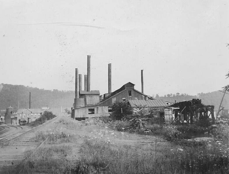
| These two images are from August 3, 1925 and show the beginning of the removal of the rolling mill along the Reading Railroad tracks behind where the high rise is located on Parkway today. This business was established circa 1869 and was considered the oldest manufacturing company in Schuylkill Haven. |


| These three images from March 8, 1925 show the Red Bridge and the Red Pond located in the area behind Edgewood and the Casket Factory. |
| These three images from April 26, 1931 show the old Pennsylvania Railroad arch at the northern end of town and the beginning of the construction of the new bridge that spanned what would become Route 61. |


| The photo at left was taken on March 28, 1920 at the northeast corner of Canal Street (Parkway) and Union Street. The photo at right was taken on April 7, 1919 and shows the home at the northeast corner of Dock Street and Paxson Avenue, looking to the rear from Paxson Avenue. |


| The photo at left is of the high school athletic field on September 2, 1923. The photo at right shows the high school (now middle school) under construction in 1917. |


| These four images show the transition of old bridge to new bridge at Broadway. At top left is the old iron bridge on August 22, 1929, built in 1872. At top right, this April 13, 1930 image shows the removal of that bridge. The two images at the bottom show the new concrete bridge on December 21, 1930. |

| This May 31, 1915 image shows the Citizen's Band of Schuylkill Haven marching north on Garfield Avenue toward the entrance of the Union Cemetery for Memorial Day services. |

| The home is this image taken on September 27, 1914 was located across the street from present day Boyer's Market at the corner of Main and Tennis Avenue. The description on the back said it was located on Willow Avenue between Canal and Callowhill Streets. Canal was renamed Parkway. I do not know the history of the other two streets mentioned as far as names changing. |


| These four images were taken near Union Street in 1931, prior to the removal of the old school and the building of the East Ward school. Top left is on Union Street looking toward Pleasant Row. Top right is Union Street looking toward St. Peter Street. Bottom left is the old school at Union and High Streets. Bottom right is looking south along High Street toward Wilson Street. |


| These three images were taken at the Reading Company storage yards below Schuylkill Haven on September 12, 1915. |

| This picture was taken on September 20, 1929 and shows the "new road" going to Pottsville toward Cape Horn, present day Route 61. Note the rocks used as safety cones on the highway. |

| This image shows the Mackey Tavern, a one time stage coach stop, in disrepair on October 27, 1921. Reiley and Sterner garage currently occupies this location. |


| These two photos were taken June 20, 1915 from the Lehigh Valley Railroad trestle. On the left the view is looking northwest and on the right looking to the south toward Schuylkill Haven. |

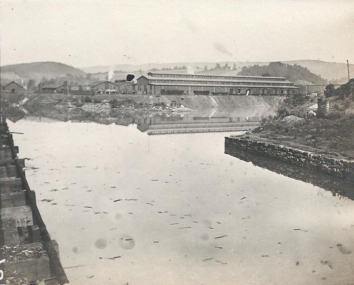


| At top left, the Schuylkill River is flooding beneath the Reading railroad bridge in Schuylkill Haven in this August 24, 1933 image. At top right,a steam powered train approaches Schuylkill Haven from the Lehigh Valley Railroad trestle in 1915. Below are two images of the Reading Railroad car shops, at left on September 11,1926 and at right on June 7, 1916. |

| The picture below was taken on October 11, 1925, looking south toward Main Street, showing the demolition of the old Reformed church which stood in front of the present day St. John's UCC. |

| This early twentieth century image shows Schuylkill Haven looking southeast from a high bank on Centre Avenue |


| These photos are from a snowstorm in Schuylkill Haven on February 7, 1920. At left is Dock Street near Coal, looking south; center is The Call building at the intersection of Dock and Main Streets and at right is Liberty Street looking east from St. John Street. |


| Shortly after trolley service between Schuylkill Haven and Pottsville was discontinued in August, 1932, the tracks were removed. This series of pictures shows that work with the final picture of a trolley car on Liberty Street. |


| These two pictures from March 6, 1987 show the destruction of the Pennsylvania Railroad arch at the northern edge of town on the east side of Route 61 near Connor's Crossing. |


| The four photographs were all taken on in January 1918; the first one on January 13 and the last three on January 27. At top left the Columbia Street bridge straddles the frozen Schuylkill River; top right shows snow on Main Street looking west from Margaretta Street; bottom left is Centre Avenue as is bottom right. |
| These photographs are from a snowstorm on February 7, 1920. Top left is St. John Street looking north from Wilson; top right is Main Street looking east from St. John Street; bottom left is Dock Street looking north from Broadway and bottom right is St. John Street looking north from near Union Street. |


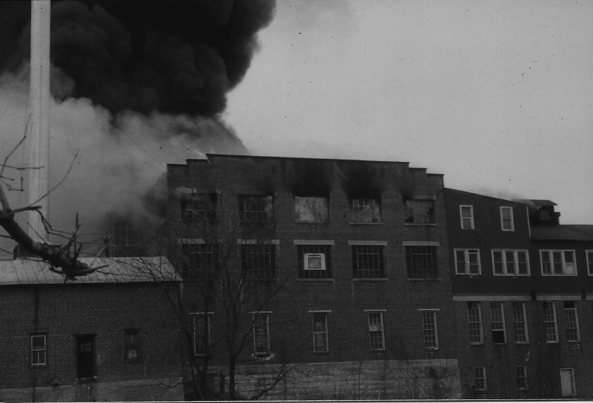


| Below are six pictures from the fire that destroyed Bast's Mill on North Berne Street on March 7, 1957. These were provided courtesy of the photographer, Dick Klahr. |


| The series of pictures below were taken in 1931, showing the removal of the old high school at High and Union Streets, to be replaced later by the East Ward Elementary School. |


| This set of pictures was taken by the engineers who helped construct the new post office on Main Street. It was Federal Public Works Project Number 346. The detail in the pictures is outstanding and can be better appreciated by clicking on each to enlarge them. The date of each picture is below it. |
| September 6, 1935 |
| September 6, 1935 |
| October 1, 1935 |
| November 11, 1935 |
| November 11, 1935 |
| December 1, 1935 |
| January 1, 1936 |
| January 1, 1936 |
| February 1, 1936 |
| Completed Project |
| May 1, 1936 |
| May 1, 1936 |
| March 1, 1936 |
| March 1, 1936 |
| December 1, 1935 |

| Photo Album PAGE 2 |

| NOTE: MOST OTHER PAGES WITHIN THE SITE CONTAIN MANY MORE DIFFERENT PICTURES |
| LAST UPDATED: OCTOBER 23 |
| NOTE: NEW PHOTOS GENERALLY ADDED AT THE BOTTOM OF PAGE 3 CLICKING ON PHOTOS ENHANCES THE DETAILS ON MOST |
| IMPORTANT NOTE: Due to page size restrictions, the PHOTO Album is now broken into three pages. New pictures will be added on Page 3. Links to the other two pages are here and at the bottom of the page. |
| Just added are another set of outstanding photographs of the car shops of the Reading Railroad at Schuylkill Haven, plus some bridge and station images, most recently appearing in the book by Benjamin Bernhart in his series on the Reading Railroad. |