
| Photo Album PAGE 1 |


| These photos portray the interior of the First National Bank (currently M & T Bank) on Main Street. On the left is the receiving window with it's impressive woodwork and barred teller stations. On the right an employee conducts business on a candlestick telephone at his roll top desk. |

| Bressler's Band, conducted by Hen Bressler, was well known throughout the area. Here they parade to a lined street. It appears to be Centre Street in Pottsville at the intersection of Mahantongo Street. |

| The view is a little hazy but this is a rarely seen view of the reception desk at the Grand Hotel which once stood at the corner of Main Street and St. John Street. |
| This picture features Schwartz's Money Back Store on St. John Street just south of the intersection of Main Street taken August 15, 1934. Above is the ad for their Grand Opening in January 1932. |


| Here are a pair of pictures taken at the intersection of Columbia Street and Berne Street. The ice house is evident to the rear of both photos. On the photo above, the warehouse for Bittle's store is in the foreground and a delivery truck across the street. The autos in the photos may help someone date them. |

| Harry Naffin, former owner of Messner and Hess, used to take pictures of buildings in town before they were torn down. Here are two he took. On the left is the American Legion hut in September of 1968, located on the current site of the High Rise on Parkway. On the right is a view of the building from William Street at Parkway. |

| As a side note: My uncle related to me that when he was a boy, the town would close off St. John Street between the bank and Stine's Pharmacy to allow Bressler's band to give concerts. He stated that prior to beginning, Hen Bressler would announce, "Kinder, ruhig weil der band spielt", Pennsylvania Dutch for, "Children, quiet while the band plays". |


| The Schuylkill Haven Police Department on May 30, 1962: Row 1: Gloria Shirey,Boyd Hale,Lorin Honicker,Mayor Bast,Sterling Moyer, Edna(Sis) Bittler Row 2:Nick Lascala,Murray,Clyde Manbeck Row 3: Clayton Bashore,Earl Dietrich,Bill Goetz,Cliff Mengle (Picture compliments of Sharon Freeman) |

| This shows a view of the Willow Lake swimming pool. Note the slides and the rafts in the middle of the pool. (Photo courtesy of Jim and Shirley Gilbert) |

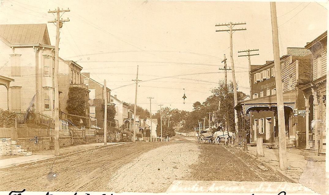
| One of my favorite pictures, shows the Spring Garden Hotel at the corner of Dock Street and Center Avenue taken in either 1894 or 1895. The hotel is bedecked with patriotic bunting for some event. |

| Alpha Mills employees gather on Margaretta Street in front of the factory. From personal memory I can identify Marge Wagner and Betty Zimmerman fourth and fifth from left in the front row; Back row: the men in order from left, Titus Miller,Barton Biever Sr.,Dick Biever,Jim Harner,Dick Miller,unknown,Bart Biever,Glenn Sattizahn. Zooming in can help you identify others. |

| Here is a progress photo of the Post Office as it was being built on February 1, 1936. |

| The ice house on Bittle's Dam (Stoyer's Dam) is reflected in the water in this early photo. Circa 1930, the "Sugar Bowl" was located at the upper end of the present day park. It was a swimming pool located on the creek flowing into the dam. Access was gained by crossing a bridge over the "moat". The pool had a bath house, diving boards and a shallow end for children. Water from the creek was filtered through a large sand filled tank before entering the pool. It was later abandoned and mostly forgotten. My uncle related the story that the Feeser family had some interest in the business. I spoke to Tom Feeser Jr. who talked with his father, who recalled the pool but could not remember his father Paul's exact involvement as he was only a child. According to "Bright Spots", Dr. G. H. Moore of town was also involved in having the pool constructed. |

| This view looks west at the railroad crossing at Main Street. River Front Center (formerly Troutman's Hardware) now occupies the site. Note the crossing shanty at the right with crossing gate. |

| Here are two images of Bast Mill on Berne Street located where the Berne Street playground now exists. Above is a picture from 1898. At right, the picture was taken from the Columbia Street bridge about fifty years later. |

| This picture from taken form the lot at the former Earl Stoyer car dealership (now the Losch Wash) looking south toward Columbia Heights. The area is much less developed with homes then today. |

| This view is looking in the general direction of the picture above but from an earlier time. The ice house is seen on what was then known as Bittle's Dam (Stoyer's Dam). |


| Here are two views of the Irish Flat in September 1968 in the midst of redevelopment of the Island. On the left is a view of Jacques Street and on the right is Broadway. |

| This picture shows the Earl Stoyer car dealership at the intersection of Berne and Columbia Streets. Losch Plumbing and Heating now occupies the building. I am unsure of the date but perhaps a visitor can date it from the cars on the lot. |


| The four pictures surrounding this text were taken in September of 1968. Buechley's Lumber Yard on the Irish Flat is seen here before redevelopment began. |

| This picture taken in August 1900 shows a bridge that crossed the canal on Parkway. By this point, the canal was no longer in use and was being filled in allowing the bridges to be replaced with streets. |
| NOTE: MOST OTHER PAGES WITHIN THE SITE CONTAIN MANY MORE DIFFERENT PICTURES |

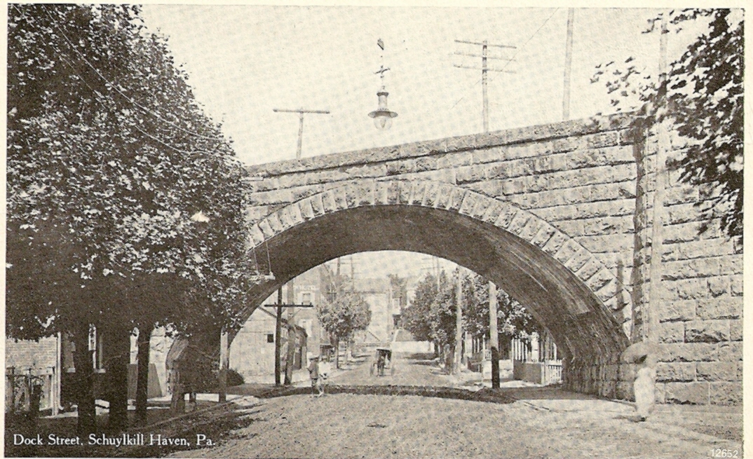
| This picture shows a piece of fire fighting apparatus belonging to the Rainbow Hose Company. The picture is taken under the old railroad arch on Dock Street above Haven Street and looks north toward Center Avenue. Zooming in on this image enhances a great deal of detail down to the name "Rainbow" on the frame. |
Photo courtesy of Carol Campbell

| In 1908, local entrepreneurs established the "Fairmount Addition" which today is known as the Avenues. Above is a map printed from a brochure printed to lure potential home builders. Zooming in on this image greatly enhances the detail. The site was formerly Boyer's farm. My wife and I raised our children at 53 Avenue C, a home we had always been told was one of the first in the development. Recent research indicates it may have, in fact, been the first home there. |
| These aerial views of downtown Schuylkill Haven were taken in March 1973. Note the differences as compared to today: the Reading Company freight station is now a parking lot, the Yoder building is the parking lot next to post office, the former state police barracks is now the site of the car wash, the Island is not yet developed, homes near the Green Goose playground are not yet built, the new elementary school is not yet built, the Methodist Church is still standing on Saint John Street and homes on Saint Peter Street that burned down in a fire and now the site of a parking lot. |

| This image captures the destruction of the March 8, 1932 fire that destroyed the Hotel Grand at Main and St. John Streets. |

| The local contingent of the Ku Klux Klan march their way down Parkway in a parade. Note the KKK pennant on the mule in the front and the hooded horseman behind him. |

| This 1912 picture of Meck's Mill at the corner of West Main Street and Parkway shows little difference from its current appearance. |

| This is a view of the I. B. Heim General Store on the corner of St. John and Union Streets. Harry Naffin related that visitors to the store would be greeted by the owner with, " I. B. Heim, who be you." The building is today an apartment building. |


| These two images show the aftermath of the blaze at the Faust apartments on Tennis Avenue. On March 31, 1965, a fire destroyed the Faust apartments in the building that was once the Sharadin Mill. The fire started about 7:15 and all three fire companies responded. Five families lost everything in the blaze. While cars in the adjacent garages were safely removed, two school buses were burned. Several explosions occurred including one that sent a cake pan out a window, striking Borough Manager Bob Gehrig on his hard hat though not injuring him. In conversation with Harry Naffin, he related his involvement in the story. He responded as a volunteer and while standing with Chief Carl Feger noticed that the fire was not venting. Feger told Harry to get two axes, stating they would then climb a ladder to the roof to cut vent holes. Harry said just as he returned with the axes to begin the task, an explosion hit that blew the roof up into the air before settling back on the walls. If Harry had been quicker, they may have been up there when the blast hit. |

| The former Borough Hall on Dock Street looks much the same today as it did here in this early 1950's view. |
| This photo shows the intersection of Union and Saint John Streets after a snowfall in 1920. Heim's store is on the left, the steeple of the Methodist Church that once stood on St. John Street is seen up the street. The home behind the trees on the right is the location of the library today. |
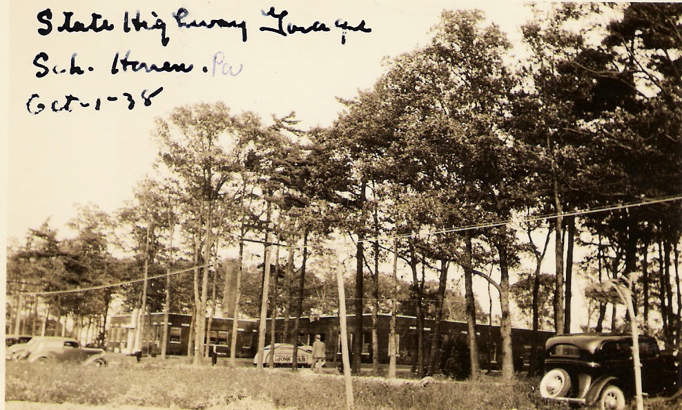
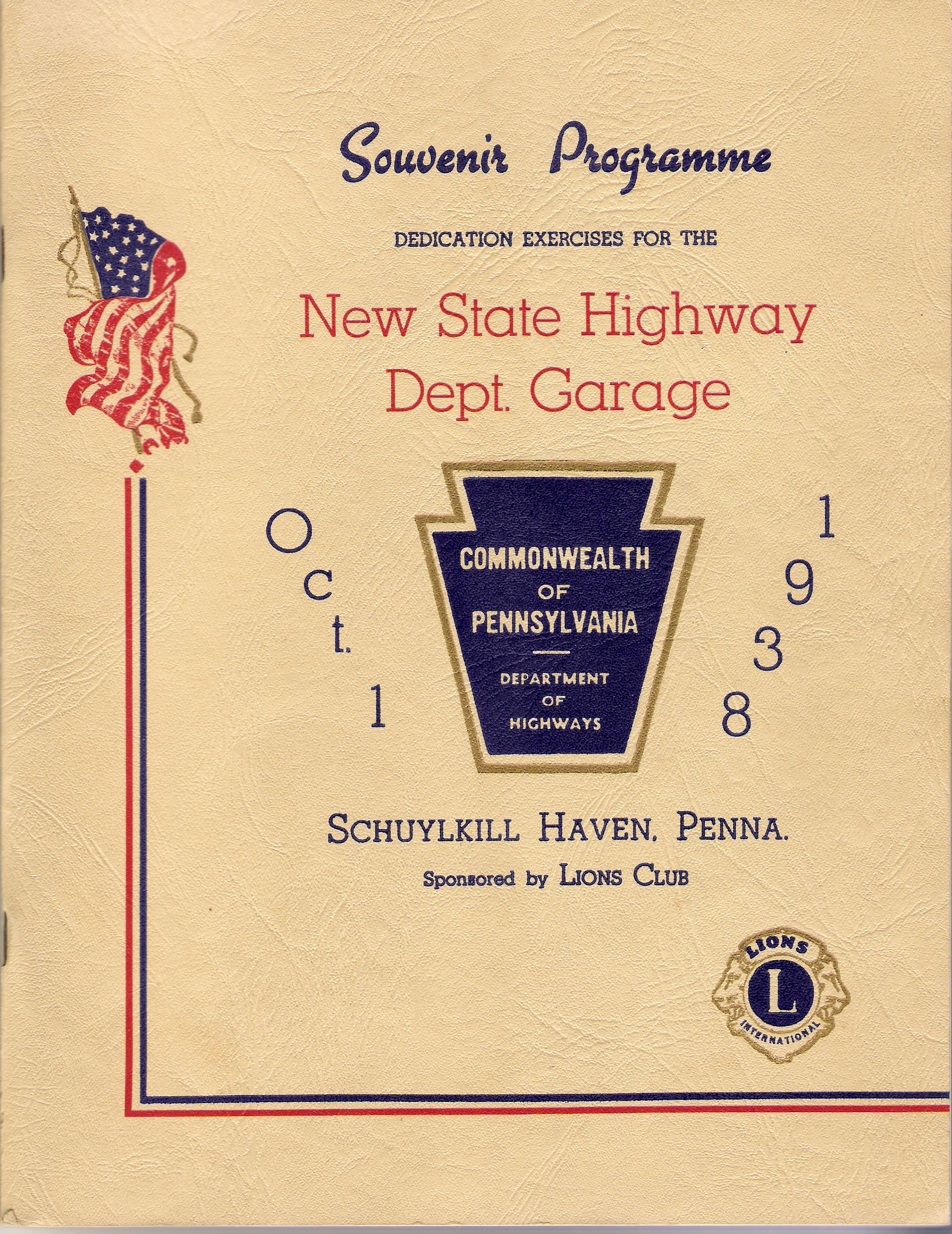
| The new State Highway Garage (PennDot)in Schuylkill Haven was dedicated on October 1, 1938. This picture was taken that day. One of the distinguished guests at the ceremony was Governor George H. Earle. At left is the cover of official program for the ceremony. |


| This view is on Union Street looking west from St. Peter Street at the current location of the Schuylkill Hose Company. |
| This picture taken in 1908 shows North Garfield Avenue looking north from the area of Center Avenue. The angle suggests it may have been taken from the railroad tracks of the Lehigh Valley Railroad as it passed through town. |


| Theses two images are taken at the intersection of Union Street and Saint Peter Street. The picture below looks down Saint Peter Street from Jackson Street with the still remaining steps on the left, the now gone street in the middle at the bottom and the old Grace Evangelical Church where the Schuylkill Hose Company now stands. The former Meck mansion is seen on the right, much as it looks today. Both pictures are from 1905. |


| This photo depicts homes and the roller skating rink on West Main Street. The rink is on the right and is the current location of Boyer's Market. The homes and the rink were built by noted Schuylkill Haven carpenter and entrepreneur, Paul Naffin. |

| Here are two more pictures from the Irish Flat before redevelopment caused their removal. At left is Yenosky's Café and on the right are family homes. |


| This set of pictures witnesses the end of the P. T. Hoy building and the adjacent Abe's Workingman's Store at the corner of Main and Saint John Streets in August of 1964. |
| The two photos above at left and right show the current municipal parking lot on Wilson Street when buildings still occupied the site. The middle picture shows a home that was torn down behind the Messner and Hess building to allow for the expansion of the store. The scenes are from May of 1966. |


| On June 12, 1960, members of the Schuylkill Hose Company received their new fire engine which meant this old Seagraves would be sold to MaryD. The photos were taken at Schuylkill Hose Company at their old location of Saint Peter and Wilson Streets. |


| On Easter morning in April of 1960, fire destroyed all the buildings between the Pennsylvania Bank and the railroad tracks. This set of pictures details the event. |


| At left is the building that once housed a dress shop on East Main Street owned by Rosalia Fleming. It was located next to the current Geschwindt Stabingas Funeral Home. Below, the building is being torn down. |


| Two 1973 era aerial photos of Schuylkill Haven show the Stoyer's Dam area on the left and the Parkway with the Hi-Rise on the right. |


| This is the building owned by Elias Ziegenfuse, furniture dealer and undertaker. It was located where the Geshwindt Stabingas Funeral Home on Main Street is now. This picture is from 1898. |

This panoramic view of Schuylkill Haven appeared as the cover of a trifold brochure
printed sometime around the Second World War as far as I can determine. It was filled
with various information and statistics meant to draw potential businesses and residents.
printed sometime around the Second World War as far as I can determine. It was filled
with various information and statistics meant to draw potential businesses and residents.


| The five photos below are aerial views taken by my son and I over Schuylkill Haven in 2004. Detail in each picture is enhanced by clicking on the individual pictures. |
| Above is the down town area with the center point near the intersection of Main and Saint John Streets. |
| Above is the area near High, Market and Margaretta Streets with the Alpha Mills near the center and the old Argo Mills in the upper left. |
| Below is the center of town looking east from Berne Street at the bottom toward the Avenues near the top. |
| Below can be seen the Haven Casket Company and the Liberty Street area. |
| Below is Stoyers Dam and Bubeck Park looking down from the Schuylkill Mountain area |
| PARKWAY |
| Parkway, located off of the western end of Main Street is considered an eye pleasing part of town. Below are five images of the area from the past. Note as written on one view, it was previously called Canal Street. |


The two views above show homes on Parkway, some of them recognizable today.
| These two images look on Parkway southward from Main Street. Several sources tell me the cannons were collected during a scrap drive for World War Two but were never destroyed and may yet be stored somewhere. |
| Looking south from the intersection with Columbia Street, the Walkin Shoe Company is on the right. |

| TRAVELING DOWN MAIN STREET |
| The following set of post cards shows Main Street in various time periods from east of Green Street to Parkway. Each view is described and dated when possible below the image. |


| East Main Street looking east from Green Street in 1906. Note the dirt street and deep gutters. |
**Note - Clicking on images to zoom greatly enhances details.
| Looking west from Haven Street in 1913. The home on the corner is still there. |
| Looking east from Dock Street in 1910. The church and parsonage on the left remain today. |
| Looking west from the vicinity of Dock Street in 1910. Buggies are transportation of the day. |

| This view looks west down Main Street from Saint Peter Street toward the railroad. |


| In 1907,these stores lined the north side of Main Street between Saint John Street and the current funeral home. |
| Years later, more change is evident in this view looking west from Saint Peter Street. |

| This 1907 view shows buildings on the south side of Main Street nearing Saint John Street. |

| Another 1907 view looks east from the Reading Railroad crossing below Saint John Street. |

| In 1917, the view east on Main Street is similar to ten years earlier with trolley tracks visible. |

| The view again from the Reading Railroad crossing but in 1929. |


| The intersection of Main and Saint John Streets with the P. T. Hoy building on the corner. |
| Automobiles now line the Main Street in this view of the business district. |

| Two Schuylkill Haven landmarks, the P. T. Hoy building at left and the Hotel Grand at right. |

| The beautiful Hotel Grand in 1906. |


| Trees line Main Street just below the railroad tracks looking toward Parkway. |
| This 1909 view shows an unpaved Main Street from just below the railroad looking west. |
| Here is yet another view looking west below the Reading Railroad crossing on Main Street. |
| Our final Main Street view shows the home at the corner of Parkway and Main Street in 1903 much as it looks today. |


| Here are two pictures of the Columbia Street bridge. On the left it is seen during its days as a covered bridge. Note the Columbia Hotel, later the VFW to the left. The 1929 view on the right shows the current bridge, much the same now as then but with light posts on each end. |

| Schuylkill Haven was once the home to the Rio movie theatre which was located on Saint Peter Street near Union Street. This program is from 1940. The cash prize is $200 since according to the back cover, Abner Miller was not present to win $150 the previous time. |

| The picture above shows the Parkway Restaurant. It is taken from the cover of a menu which causes a less then perfect image. |
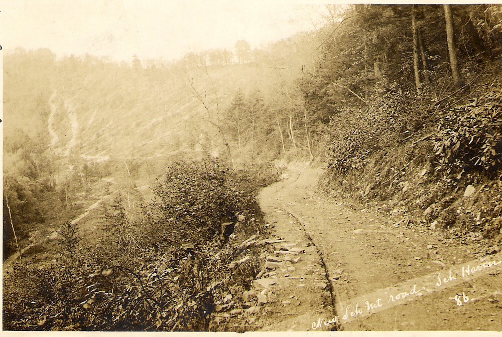


| As you leave Schuylkill Haven traveling south on Berne Street, you travel up what is known as the Schuylkill Mountain Road. A nice overview of the town is visible from the top. It is said that at one time, when the mountain was less wooded, burning crosses were occasionally observed compliments of the local Ku Klux Klan. The top left image shows the road traveling up the mountain under construction. At top right, the view shows the road going down into town. To the left we again see the road descending into town. Below is the road going up the mountain with the side road on the left leading into the storage yards. |


BIRD'S EYE VIEWS
| Many early postcards featured "bird's eye views" of towns. These pre airplane aerial views gave viewers an overall perspective of an area. Below are various views of this type of Schuylkill Haven. |
| This 1925 angle is looking from the Market Street/Saint Peter Street intersection west toward Long Run. The Walkin Shoe factory is seen in the middle left of the card. |
| This 1910 image shows Stoyer's Dam and West Columbia Street looking north from Columbia Heights. Note barns in town and the undeveloped orchard area. |

| This is a 1911 view looking north from the far end of South Berne Street. Zooming in allows one to see the covered bridge on Columbia street, the Bast mill on North Berne Street and the outdoor toilets behind the homes. |
| A young man in 1908 points toward Schuylkill Haven from somewhere above Garfield Avenue. Note the railroad tracks and overpass. St. Ambrose Church on Dock Street is in the very center. |


| Looking down from the Schuylkill Mountain over Schuylkill Haven, the covered bridge at Columbia Street is visible on the left. |
| Another view from near South Berne Street looking toward town. |


| This early photo looks towards Cressona. The Reading car shops are visible on the right middle section of the card. |
| This view from North Berne Street gives a nice overview of Schuylkill Haven. |


| A BANK OF CHANGING FACE AND NAME |

| The bank at the corner of Main and Saint John Streets was established there in 1904 as the First National Bank of Schuylkill Haven. It later became the Pennsylvania Bank and later underwent more name changes until becoming the M and T Bank today. At upper left is the bank as seen in 1909 and above right, the same bank in 1917. The picture at below left shows a new structure in 1937 and below right, the bank resembles its current state. |


| The two pictures below show the arch of the Pennsylvania Railroad where it crossed Dock Street at the intersection of Haven Street. At left, a horse drawn buggy is seen in this early 1900's view while at right early autos are seen in this 1930's view. |


| At left Is Columbia Street when it was a tree lined street, looking west from Parkway. At right is the Broadway Bridge, leading to the Island or the "Irish Flat" as it was known at one time. |


| This is the original building of the Schuylkill Haven Trust Company which later housed Stramara's Sub Shop and now the Uptown Tavern. |

| This photo shows the business of William J. Saylor Jr., plumber, supposedly on Main Street in town. A note on the card says, "still doing business at old store, Bill". The location is at 214 East Main Street. |


| The following seven photographs are all related to the P. T. Hoy building at the corner of Main and Saint John Streets, where Brok-Sel now is located. These pictures were kindly provided by Lewis Hoy, descendant of P. T. Hoy, as were the following two. They were taken by his father, Lewis H. Hoy, except where noted. |
| This view of the Hoy building in 1902 shows it looking north from Saint John Street. The barn and stables are behind the store. The young boy walking along the sidewalk near the barn is Rudy F. Hoy, Lewis H. Hoy’s brother, the man who ran the store from 1920 until its closing. The Hoy property consisted of the entire block with the exception of a small parcel between the Hoy Building and the Hoy barn and stables. In the 1930’s the Dr. Lessig home was built on that parcel. P.T. Hoy acquired an existing building on this site. The front portion was demolished to permit construction of the new store and above, 2 ½ stories of living quarters, which were constructed shortly before 1900. The older rear portion was retained from the earlier structure which contained a “lodge hall” used for many years by the GAR post. This older portion had a unique feature of having a first floor below street level, the result of the filling and raising of Main and St. John Streets. to the level of the P&R Railroad tracks at the crossing. The framing of older store fronts could be seen in the basement. A portion of the west end of the old building was also incorporated into the Hoy living quarters. This area is identified by the porch along the sidewalk, the location of the front door and the downstairs parlor window. There was a grand parlor on the second floor fronting on Main Street. |
| Also from 1902 is this image of Pottsville Union Traction’s Pullman built car in front of the store on the Saint John Street side. Note the beer wagon unloading at the Hotel Grand. The arc light hanging over the street is significant. This was the first electric light in the town when the power plant in Schuylkill Haven went into service. Lewis H. Hoy as a boy was present at the inaugural “throwing of the switch” at the power plant. |
| This is the window exhibit of the Hoy store, displaying new products that were being introduced at the turn the century. The salesmen would spend a week living at the Hotel Grand and samples of food items would be made available at the counter behind this window. In this window among several items appears to be a Pinocchio figure. To the right there is a woman in the background smiling. Lew believes this to be his Aunt Helen, his father’s sister. Lew never met his aunt, as she died giving birth about 1924. |
| The interior view of the store, which handled all products such as dry goods, lamps, and any necessities. The woman in the photo is Christine Hoy, Lewis Hoy's father's older sister. The store sold flowers at Easter and always had barrel molasses available. The molasses barrel with the crank pump was located immediately to the right upon entry from the Saint John Street door as was the counter. Note the gas lighting fixture. This was the first store in Schuylkill Haven to have complete electric lighting, installed by Lew’s father when he was General Manager of the store, perhaps around 1908. Because the building was wired, the store also had one of the first electrically operated cash registers with an internal accounting system and printed tape receipt. This device lasted until the store's closing. |
| The Hoy parlor (in the “older” first floor section of the building), date uncertain, but after the store and home were wired for electricity. These electric trains were well known to residents of Schuylkill Haven just prior to WW I. They were displayed in the store for several years at Christmas time (the first electric toy trains in the town). They were an exceptionally appealing attraction to draw people into the store. When first displayed they were tended by a young man whose father was the engineer on the Reading’s “Flyer”, Trains #92 (southbound) and #97 (northbound), the fastest trains to and from Philadelphia. The engineer’s name was Moyer. His son later started Moyer Electric in Pottsville . He was then a school student and manned the train exhibit after school. |
| At left, a view taken from the Hoy property looking toward Main St. and the Hotel Grand during a snowy day. Note the Hoy hitching post. The Hoy store had the first motor truck to operate 12 months of the year in Schuylkill County . For this reason it had the first public gasoline pump in town. At right, a scene of the Hotel Grand corner during a snowstorm in 1920 taken by the East Penn’s claim agent John A. Mower of Sch. Haven, when a major effort was involved in getting the line open. |
| At left, another Mower photo shows the cleared trolley tracks near the Saint John and Liberty Streets intersection circa 1920. Above is Dock Street looking north between Main Street and Paxson Avenue. |


ARGO KNITTING MILLS
| This set of five photos is from the Library of Congress archives. They show the Argo Knitting Mill on Margaretta Street near Market Street. The pictures are from 1953. The building is now part of Alpha Knitting Mills. |
| Churches of Schuylkill Haven |

| Here is the Methodist Church when it was located on Saint John Street. It was relocated to Saylor Street after burning down in the early 1980s. |
| This 1911 picture shows Saint James Episcopal Church at the corner of Dock Street and Paxson Avenue looking much as it does today. |


| This 1937 image shows Saint Ambrose Catholic Church and rectory on Dock Street. The new church is located on Randal Street near the eastern end of town. |
| Originally called Strunck Memorial Hall and looking much the same today, it remains the home of Saint John's UCC Church at the corner of Dock and Main Streets. |


| This 1910 postcard shows the United Brethren Church on Main Street near Margaretta Street along with views of the old parsonage and the new parsonage which remains today. |
| Here is Saint Matthew's Lutheran Church as seen in 1910 Main Street. It merged with Christ Lutheran after the burned down creating Jerusalem Lutheran Church. |


| In 1906, Grace Evangelical Church was located at the corner of Saint Peter and Union Streets, the present location of the Schuylkill Hose Company. |
| Christ Lutheran Church was located on the ground occupied by Jerusalem Lutheran Church on Dock Street until fire destroyed it. |
| This 1913 view of Saint Matthew's on Dock Street also shows the adjoining parsonage looking much as it does today. |
| Saint John's Reformed Church located on Main Street where Saint John's UCC is today. This is looking north down High Street. |

| This nice 1907 image looks south on Saint Peter Street from Main Street. Dr. Roberts now occupies the building on the left. Note the homes on the right side of the street now occupied by the Sovereign Bank. The homes on the left burned down in a fire in the early 1980s. |

| The Gerber Shoe Factory occupied the corner of Parkway and Columbia Street in this 1909 picture. Note the bridge over the canal on the left. |


REST HAVEN
| Today Rest Haven exists as the county retirement home for the aged. Over the years it has been known as the Insane Asylum, the Poor House, the Almshouse and other monikers. While not within the proper boundaries of town, it has always been linked with Schuylkill Haven. Below is a series of images of the area. |


| These two early views show the complex from what is currently Route 61 looking north. |
| These are two more overall views at a later date. |
| This set of four pictures show various buildings at the Rest Haven complex. |
| Below are two more panoramic scenes of the buildings as they existed. |


| Both of these undated photos show businesses in Schuylkill Haven. On the left is Ehly's Bakery on Dock Street located where the Jerusalem Church now stands. At right, are two unidentified persons surrounding the sign for Heister Klahr's Restaurant, believed to be on Dock Street also. The man on the right may be Heister Klahr. BOTH PHOTOS COURTESY OF SUSAN SHOMPER DOYLE |


| This circa 1918 photo shows a young man by the name of Frank Fox of Schuylkill Haven. The back of the photo states he was a champion skater at the Roller Rink in town which was located where Boyer's Market is today. The rink was built by the prolific Schuylkill Haven builder, Paul Naffin. |


| The cutting room at Meck's Mill is shown here. The man on the left is identified as Warren Leeser. PHOTOS COURTESY OF SUSAN SHOMPER DOYLE |
| The exact location of this home on Main Street is unknown. It housed a business owned by the Luckenbill family. |


| The set of seven photos below show the Esso gas station on Dock Street where the Chinese restaurant is now located. The images were taken by Freeman Shomper as he prepared to take over the business that was formerly Moyer's Service Station. PHOTOS COURTESY OF SUSAN SHOMPER DOYLE |

| These two pictures show employees of Meck's Mill in a parade. The date and event are unknown. |

| A parade of unknown date and event passes the intersection of Union and Saint John Streets. |
| THE DEMISE OF GRACE EVANGELICAL CHURCH This set of eight photos records the razing of Grace Evangelical Church at the corner of Saint Peter and Union Streets, current location of the Schuylkill Hose Company. The slides were printed in April 1974, which should be an accurate date of about when this occurred. |


| SCHUYLKILL HAVEN'S 225 TH ANNIVERSARY PARADES IN 1975 In 1975, Schuylkill Haven celebrated it's 225 th anniversary. Below are scenes from the long parades that were held. There was a firemans parade in June and a civic parade in August. You can distinguish the pictures below by knowing that it rained for the civic parade. |


| At left, the parade begins with the official banner leading the way. On the right the Schuylkill Haven High School Band marches up Main Street. These photos were taken, as all the following were, from in front of Messner and Hess, looking west down Main Street. All photos were taken by Harry Naffin. |


| At left is a fire company group marching and at right is the Schuylkill County Motorcycle Club. Looking at these pictures, you can identify businesses no longer here. The building with the Dr. M. M. Maurer, Chiropractor sign was torn down many years ago and once housed Raudenbush's bakery in the lower floor. Stine's Pharmacy has since been sold and the Pennsylvania National Bank has been renamed several times. |


| The gentleman in the rear of this dune buggy appears to be the mayor of the day, Nick Lascala. On the right is Paul Donmoyer, who was later mayor of town, in front of the Bonnie Jean shop which no longer exists and riding in a car emblazoned with the now defunct Earl Stoyer car dealership advertising. |

| The car on the left carries Marion Singer, the queen from the town's 175th anniversary held in 1925. On the right is the queen for 1975, Micki (Emerich) Casey. Note Jack's Shoes and Things in the background. |

| The float on the left carries the contestants for princess. Do you recognize any of them? On the right is Main Street prior to the start of the parade. The reviewing stand is set up on Saint John Street next to the bank. |


| On the left, Messner and Hess is decorated for the celebration as is Charlie's Sports Center, both long gone. The pharmacy on the right was owned by Dave Schimpf, who was very active in the event. |


| The A and P store before it went out of business now is the home of Boyer's Food Market on West Main Street. |

| MYSTERY PHOTOS |
| The following photographs are from the collection of Harry Naffin. None are identified as to exact location nor are the individuals known. Most certainly they are from Schuylkill Haven. If anyone can identify the locations of these photos, it would be of interest to many. |


| This image shows the interior of Doutrich's Store which was located on Main Street near the railroad tracks. |


| The three photos above depict the Ebling Garage on Dock Street. The building was demolished in 2010 and was located directly behind the North Ward Social Club. The date of the photos is believed to be in the late 1930's into the 1940's. |
| This 1906 image shows a delivery wagon in front of the Spring Garden Hotel at the corner of Dock Street and Centre Avenue. |

| This 1906 image depicts North Berne Street. Many of the homes are still recognizable today. |

| 1906 was also the year of this image showing the hotel at the east end of the Columbia Street bridge, which was a covered bridge at the time. |

| The rolling mill located along the Reading Railroad tracks west of Union Knitting Mills is shown from the west at top and the east at bottom. |
| LAST UPDATED: OCTOBER 23 |

| This is the store front for Hartman's Liquor Store and Underwood's as seen in about 1910. The location is currently the parking lot for the post office and borough hall. The four adults are from left to right: David Detweiler, Christine Raudenbush, Ike Huy and E. G. Underwood, the owner and proprietor. |

| The photo at right is a copy of the original photograph taken by H. S. Deibert, August 7, 1894. Washburn's Circus was exhibiting on the mule yard, the square in Schuylkill Haven now (1931) bounded by Canal Street, Union Street, Tennis Avenue and West Main Street. The man on the ladder dove into the net beneath. |

| This photo is undated but it is believed to be from the 1920 era. It is taken in Mount Gretna, Pa but shows the National Guard Newspapers from the time period show a large and active contingent from town. |


A hunting we will go.......
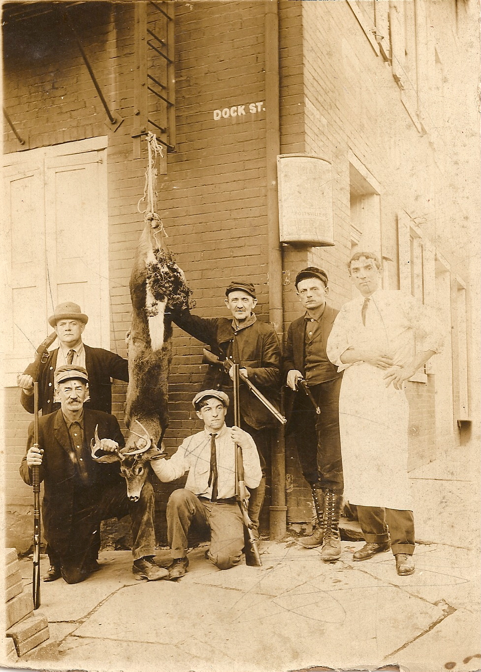
| Schuylkill Haven has long been the home to many hunters. The following five images provided by Sue George depict some hunters from the early 1900s. |
| Both pictures here depict the same fallen buck in 1914. The picture was taken at the corner of Dock Street and Centre Avenue at the building now housing the North Ward Social Club. It was at one time the Spring Garden Hotel. The man in the apron was a butcher whose shop was next door. The burly man with the mustache in the photos is Clayton Bubeck and the man with the rifle and wearing a tie is Clyde Bubeck. Joel Stump is the man second from right in both photos. Samuel Ruch is on the right in the left photo and holding the deer on the right photo. John Ebling is the man in the derby in both photos. |
| This fine looking group of gentlemen are shown in front of their hunting cabin and were known as "The Schuylkill Rangers". |
| This photo was taken in front of the cabin in 1922. Identified from left are Ebling, Charles Burns, William Dietrich, Samuel Ruch, unknown, Joel Stump, Quinter, Clyde Bubeck, Heim, Clayton Bubeck, unknown. |
| John Bubeck, on the right, joins another hunter with the results of the hunt. Note the sign for the Spring Garden Rifle Club near the roof line. Below is a token from that club in Schuylkill Haven |


| Schuylkill Haven Pirates |
| Like many towns, Schuylkill Haven had its own baseball team. They were known as the Pirates. As with many pictures on this site, zooming in on them brings out incredible detail. |
| This shows the team in 1906. Back row: Clyde Bubeck (P), Joseph Kaufman (OF), Edward Berger (P), Lewis Emerich, Robert Fitzpatrick (RF), Albert Weist (C), Robert Sausser Front Row: Raymond Shappell middle. Other three are unknown. |
| The team in 1913. |

| Painter Clyde Bubeck balances on a ladder at Saint Matthew's Lutheran Church on Dock Street in 1918. |

| The Van Buren Chorus, 1940s era group from Schuylkill Haven seen in the current middle school building. Minstrel shows were one part of their repertoire. |


| BACK IN THE SEVENTIES |
| The following four photographs were kindly provided by George Lord. At top left is the Pennsy Railroad arch on South Garfield Avenue looking from Center Avenue with Bashore's Knitting Mill on the left. Both are now gone. At top right is a picture of the defunct Schuylkill Haven Trust Company in December 1971. The homes behind it on Saint Peter Street burned in the early 1980s. At bottom left is Jean Lord, Miss Schuylkill Haven in 1968, in a parade in Wellsboro, Pa. At bottom right is Dock Street looking from Haven Street toward Centre Avenue in December, 1971. The home directly ahead with the awning is now gone. Note the old Christmas lights on the telephone pole. |

| The Schuylkill River had apparently spilled out of its banks in this photo taken on September 24, 1924. The location is the corner of West Main and Saint Charles Streets, with the Reider Shoe Factory in the background. |


| The images below are from the parade for the 175th Anniversary celebration held in town in 1925. The top two are taken on Main Street. The people in the left photo are dressed in rather formal attire while those in the right photo appear to be dressed as pilgrims. In row two, the left photo is on Main Street and the right photo is the IOOF float on Saint John Street. In row three the left photo shows a float at the Reading Railroad tracks on Main Street and on the right the children marching may be wearing white hoods as the KKK had a large presence in the parade. In row four. a marching band appears on the left and a float with a pretty girl aboard is on the right. |

| Below is an image of the Bast Knitting Mill on Berne Street as seen from across the river on Main Street (current location of the Berne Street playground) |


| Both of these photos come from a Schuylkill Haven album from the mid 1920's. Can anyone identify either location? |


| Below are three aerial photos of Schuylkill Haven which are great for comparing changes over the years. The pictures were taken by the Pennsylvania Geological Survey. The years the photos were taken are from left to right: 1938, 1958 and 1971. I have purposely left the photos in a smaller size as they are better viewed by clicking on the photo to accentuate the detail. |
| The following images were taken from a brochure from the D. M. Bittle Funeral Home located on Main Street. It was printed in the late 1930's. |


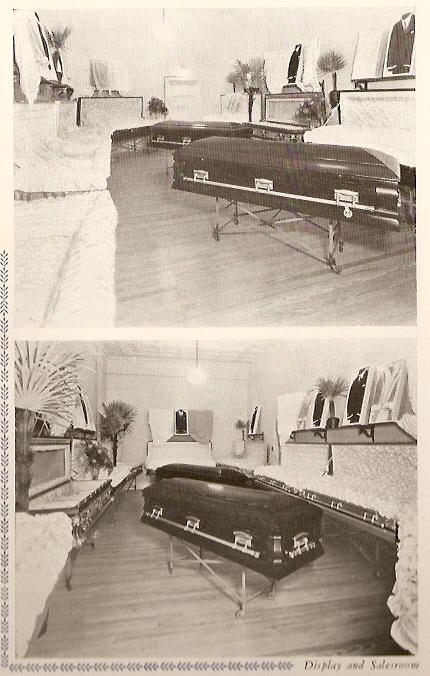
| David Bittle, at upper left was the owner of the funeral home at the time, his picture and that of founder Eli Ziegenfus, at upper right, flank a picture of the business in the late 1930's. The five pictures in the lower row are interior scenes from the funeral home. |


| SCHUYLKILL COUNTY HOSPITAL FOR THE INSANE The 1912 building at what is currently called Rest Haven, was dedicated October 30, 1913 as part of the Schuylkill County Hospital for the Insane. Below is a series of images taken from the program given to each attendee that day. The images have been left in thumbnail so that clicking on them enhances the detail. |

| NOTE: NEW PHOTOS GENERALLY ADDED AT THE BOTTOM OF PAGE 3 CLICKING ON PHOTOS ENHANCES THE DETAILS ON MOST |

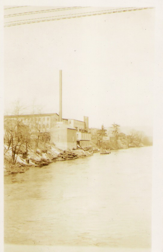
| Schuylkill Haven generated its own electricity at one time from the building on Haven Street. Below is a picture of the original building and at right is the newer structure, still there today. In the picture below you can see the Pennsylvania Railroad tracks in the rear. The remnants of the smokestack remain today. |


| BRESSLER'S BAND |
| Below are pictures related to Bressler's band of Schuylkill Haven, led by Henry Bressler. The first is a view of the band in an advertisement for their services. Below that is a picture of the band posing outdoors. |
| At left is the Independent Cornet Band of Black Horse, located in Wayne Township, led by Henry Washington Bressler whose picture is on the right. |

| This image depicts Merlie Fisher's Barber Shop when it was located on Main Street. Identified from left to right are: Merlie Fisher, Carl Fisher and George Moyer. In 1937 the shop was moved to Parkway. |

| The family of Lewis and Elizabeth Bitzer pose at their home on Berne Street where it turns sharply to the left onto Schuylkill Street, current home of Joe and Arlene Quesada. |
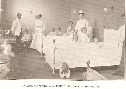
| This 1900 era image shows the children's ward at the Almshouse at Schuylkill Haven. |

| This picture shows Clarence W. Heffner, owner of Heffner's Meat Market, which was located on the side street off of North Berne Street just north of the traffic light. He is shown here with champion steers bought at the Pennsylvania Farm show in either 1956 or 1957. |

| This picture taken inside the Schuylkill Haven Post Office shows D. D. Coldren at the counter with his dog, Czar. The date of the photo and the woman behind the counter are unknown. This is the dog which Mr. Coldren had immortalized in concrete on the front of his mill. |


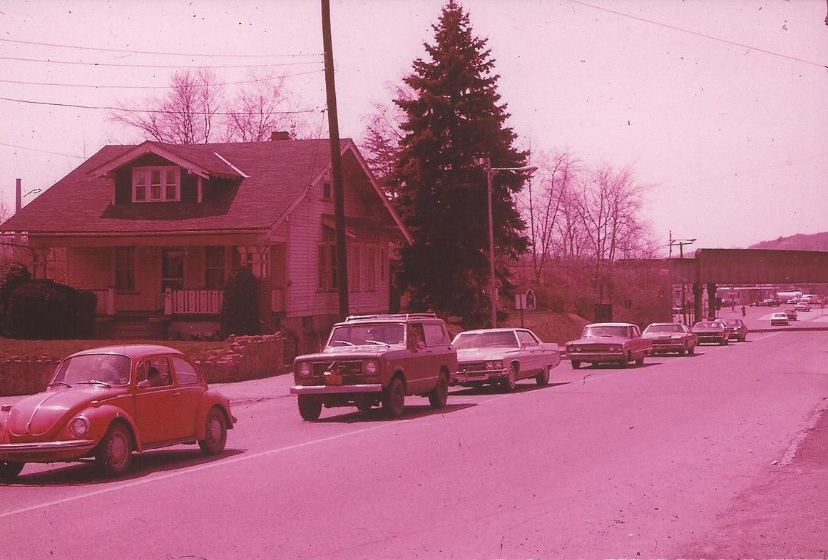
| These early 1970s views show the bridge of the Pennsylvania Railroad where it crossed Route 61 at Schuylkill Haven's northern end. On the left you are looking south and can see the sign for the Acme (current location of Denny Electric and Sherwin Williams) and Fehr's Esso station. On the right, you are looking north and can see the Buzalko home where the auto parts store is today. |
| REDEVELOPMENT IN THE NORTH WARD In the early 1970s, redevelopment began in the North Ward area of Schuylkill Haven. This included the removal of the Pennsylvania Railroad tracks and arches stretching from Haven Street, across Garfield Avenue and continuing across Route 61. It also involved the removal of homes on Coal and Berger Streets long with those on South Garfield Avenue. These pictures show the area before the destruction. These photos were converted from old slides resulting in some red tinting from age discoloration. |


| The picture at left gives an overview of the area from above what was Hummel Buick at the time and today home of Reiley and Sterner. Note the body and fender shop which is the current location of a bank and the Pennsylvania rail line running behind the homes. At the right is the old Butz home which was located on the corner of Center Avenue and Garfield Avenue. |
| Both of these views are of the Pennsylvania Railroad arch crossing South Garfield Avenue looking north toward Center Avenue. Dr. Zawisa's office is located in the left foreground today. |


| At left is a view of the arch looking south on Garfield Avenue from Center Avenue. At right is a view of the arch over Dock Street looking south from Center Avenue near the North Ward Social Club. |
| The two views here show the arch over Dock Street. At left is a view looking north from just below Willow Street. Note the Haven Tavern sign at left and Klahr's Grocery store at the intersection with Haven Street. On the right the view is from Haven Street looking toward the intersection. |
| Two views showing the Dock Street arch before its final demise. At left the view is looking north from Willow Street and at right the view is looking south from Center Avenue. |


| The view on the left shows the south side of the block of Coal Street looking west from Dock Street. The view on the right shows the same block looking east from South Garfield Avenue. |
| The photo at left shows the north side of Coal Street looking west from Dock Street. Hess's Concrete tower is visible at the rear, formerly Feeser Supply Company. At right are garages to the rear of the Butz home at Center Avenue and Garfield Avenue. |

| These four pictures above are of homes in the area of Garfield Avenue near Coal and Berger Streets. The only one I can positively identify is at upper left which was located across from the present day Spotts Brothers warehouse. Below are three views on Center Avenue during the process. |


| The three photos below show the Bittle Grocery Store warehouse located at the corner of Columbia and Berne Streets before it was demolished. It is the current location of Turkey Hill. |


| Below are two views of the Pennsylvania Railroad arch that passed over Seven Stars Road near Connor's Crossing before it was removed. In the picture at left, the Earl Stoyer Used Car lot is in the foreground along Route 61. The picture at right is coming from Seven Stars toward Route 61. |


| This view shows the north side of Main Street looking west from Saint Peter Street. |
| This building stood next to P. T. Hoy's on Main Street and prior to Jayne's it was Abe's Workingman's Store. |


| Below are two views on Dock Street. At left is a view of the homes on the east side of the street between River Street and Paxson Avenue in the distance. At right is the Trinity Episcopal church, the building still standing today |


| The photo on the left is of Saint John's float but more importantly it gives a great view of store signs along the north side of Main Street. Check them out and see how many you remember. The photo at right is of the Blue Mountain High School band. It is special to me because the young lady on the left carrying the banner was my late wife, Lynn. |

| The Soldier's Memorial on Parkway. |


| This old photo shows the interior of the former Saint Matthew's Lutheran Church on Dock Street, obviously decorated for a Children's Day. This is the church in which I was raised and the beautiful painting of Christ above the altar was still there when the church merged with Christ Lutheran to form the Jerusalem Lutheran Church. |
| .......keep checking back for additions to the page...... |
| IMPORTANT NOTE: Due to page size restrictions, the PHOTO Album is now broken into three pages. New pictures will be added on Page 3. Links to the other two pages are here and at the bottom of the page. |
| Just added are another set of outstanding photographs of the car shops of the Reading Railroad at Schuylkill Haven, plus some bridge and station images, most recently appearing in the book by Benjamin Bernhart in his series on the Reading Railroad. |